The Tena Valley should be understood as the area stretching from the French border at El Portalet to the narrows of the Santa Elena bridge, popularly known as the ‘zoque’, where the orographic valley of the River Gállego opens up.
The valley brings together a group of villages, with their corresponding municipal boundaries, which throughout history have constituted an administrative and organisational unit based on the use of communal property, notably the mountain passes.
In this sense, in the case of the Tena Valley, we can speak of a unique administrative organisation that remained in force until 1836 under the existence of the so-called ‘quiñones’, which were made up of the Quiñón de Sallent in the north, formed by Sallent and Lanuza, the Quiñón de Panticosa in the west, which grouped together Panticosa, Hoz de Jaca, El Pueyo de Jaca and Exena (which disappeared in the 16th century), and finally the Quiñón de La Partacua, which comprised the municipalities of Tramacastilla, Sandiniés, Piedrafita, Búbal, Saqués and Politura and the annexes of Casa de La Artosa and Pardina de Estarluengo (the latter two having disappeared).
The quiñones, administered by the General Council of the Tena Valley, had regulatory powers and could issue rules or statutes on matters of general interest to the valley, usually relating to the management of pastures or other shared resources, as well as practices of common interest or the delimitation of dates of use, facilitating the organisation of the residents in response to the needs of life in the high mountains.
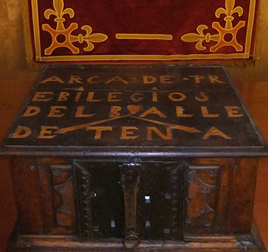
The Ark of Privileges of the Tena Valley, a symbol of unity and organisation of the three quiñones, housed the documentation and privileges of the valley. With its triple lock, each quiñón had one of the three keys and could only be opened jointly. The ark is currently kept in the Panticosa Town Hall.